


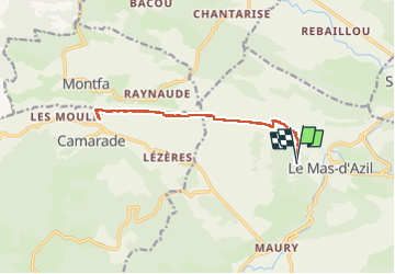
Dolmens le Mas d'Azil

loic09
User

Length
13.7 km

Max alt
587 m

Uphill gradient
302 m
Km-Effort
17.8 km

Min alt
428 m

Downhill gradient
305 m
Boucle
Yes
Creation date :
2024-06-02 07:04:19.931
Updated on :
2024-06-02 11:37:38.979
3h42
Difficulty : Easy

FREE GPS app for hiking
 SityTrail
IGN / Geographical institutes
SityTrail Plus
The world is yours!
About
Trail Walking of 13.7 km to be discovered at Occitania, Ariège, Le Mas-d'Azil. This trail is proposed by loic09.
Positioning
Country:
France
Region :
Occitania
Department/Province :
Ariège
Municipality :
Le Mas-d'Azil
Location:
Unknown
Start:(Dec)
Start:(UTM)
365744 ; 4771133 (31T) N.
Comments
Départ du parking du Cap Del Puech, dolmen de Brillaud, dolmen de Coumenge et retour